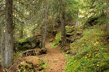
© altitude rando

Clairiere des Condus
A hike above Tignes Les Brevieres with views of the dam
This walk can be completed in 1.5 - 2 hours depending on your departure point in Tignes Les Brevieres.
One of your options is to start from the Tunnel du Brevieres, which starts on some steep switch backs and works its way up. The other starts from Les Brevieres village, crossing the D902 road and onto the trails.
The preferred route takes you, from either start point, towards a rocky outcrop on the hillside called the Claireiere de la Croix du Bario.
On the way down from here follow signs for "Nazonde" and traverse the hillside crossing two streams as you go.
If you started from the parking spot, follow signs for the parking at "Chevril" otherwise keep descending back into Les Brevieres village.
Worth knowing
This area is home to herds of sheep, so dogs must be kept on a leash at all times. Take care when crossing the road.
What to bring
The route can found on IGN map 3633ET Tignes/ Val d'Isere and in the 'Les Sentiers de L'Ete' booklet available from the Maison de Tignes tourist office.

![a picture of a hotel suite at [itemref]](https://cdm0lfbn.cloudimg.io/v7/_images_base_/image_uploader/photos_e2/original/campanules-174-suite.jpg?ua=1579868018&p=carousel)